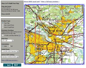
Topographical maps are a great resource and will become absolutely invaluable if T-SHTF. Topo maps allow you to do so much more than your standard road atlas in that you can accurately plot routes (if on foot with a compass), estimate elevation and easily identify major terrain features around your homestead. Recently Ranger W. wrote an outstanding …
Tag: Prepper Maps for SHTF
Recent Posts
- A Prepper Update and World Travel
- Food Storage Basics Video
- IF T-SHTF Right Now: What’s Your Status?
- Try NOT Watching the News for a week
- Home Defense Firearms Considerations
- No Need To Be Chicken Little: The Sky Is Not Falling (Yet)
- Our Next Big Test (Since Covid)
- It’s Been a SHTF Sort of Year
- The Stop Gap to Power Outages: APC Battery Back-UPS
- What Does Layered Home Security Look Like?
- Pet Prepping: Dog Food or Table Scraps?
- Stocking up for Feminine Hygiene
- Baking Bread in a Cast Iron Dutch Oven
- Insured Against LIKELY Disasters? Many Are Not.
- 4 Reasons Why You Should NOT WORRY About Nuclear War
Can’t Find It?
Categories
- Agriculture
- Alternative Energy
- Articles of Interest
- Ask The Maj
- Bartering
- Bladed Instruments
- Body Armor
- Bugging In
- Bugging Out
- Communication
- Concealed Carry
- Coronavirus COVID 19
- Distillation for SHTF
- Do It Yourself (DIY)
- Family Pets
- Featured Vids
- Food Storage
- Guest Contributions
- Guns and Ammo
- Land Navigation
- Literature
- Maj's Bugout Log
- Medical & Hygiene
- Natural Disasters
- New Preppers
- OPSEC
- PJ's Corner
- Power Grid
- Precious Metals
- Prepper Community
- Prepper Fitness
- Prepper Updates
- Prepping Strategies & Skills
- Primitive Skills
- Product Reviews
- Shipping Container Shelters
- Social Media
- The Economy
- The Homestead
- Transportation
- Uncategorized
- Water


Recent Comments